Usability of the Database
Database Usage Cases:
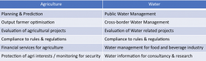
There are two subsets of use cases of the Global Vegetation Database identified*: water use cases and agricultural use cases, which are listed below:
How can YOU use the Global Vegetation Database 3.0?
Farming cooperatives
Information and decision support systems enable farmers to predict yields. These systems are able to improve the income of farmers by detecting the quality of the crops and provide irrigation advise accordingly. Hence, farmers can optimise their productivity and produce more sustainably by using water more efficiently which would eventually increase their chances of accessing to financial services as their prospects raise.Government agencies
The database is an independent tool for authorities to monitor and manage the ecosystems in their territory e.g. efficient use of their natural resources. Thus, they can realise more sustainable water usage, reduce negative impacts of climate change, et cetera. They also need to evaluate water and agricultural projects in order to decide which types of programs to fund in the future. The data helps governments also to estimate the amount of food that will be produced to help farmers with making decisions. The policies of national governments affect the water availability in other countries. Reliable and objective data helps international bodies to resolve issues related to cross-border water management. Furthermore, these data help to determine if countries are compliant to agreements and (international) rules & regulations related to farmer activities and water usage.Research and development institutes
Universities: In some countries, universities are utilised to get the needed information as value adders, delivering information to the government or governmental agencies. They need datasets for research purposes to get a better understanding of water use and availability and also crops and agriculture.Local public water organisations
Waterboards, irrigation agencies, national water level resource departments and national river basin organisations are the main public users of the database related to water management.They use the database for water management, early warning of drought and floods, and for operational support related to the water supply in the region.NGOs
Non-profit organisations can help by monitoring the crops and warn for drought or rain. They are able to support farmers or governments with satellite data. The database is free to use and open access, which is often needed by NGOs as they often have limited budgets and are required by their donors and sponsors to measure the effectiveness of their (water related and agricultural) projects. Many NGOs and donors work in many different regions around the world. Information regarding the regions is crucial to plan their activities effectively (and to set their priorities)Commodity traders
Commodity traders need agricultural data for strategic and tactical purposes. The data can strategically be used to understand and predict yields and market prices, so that the strategy can be more optimally planned and the market prices for e.g. sugarcane, rice and cotton will be more stable. Furthermore, investments in infrastructure can better be assessed based on long term data.Consultancy firms
Private consultancy firms provide water related consultancy to public and private organisations. Water related data helps these organisations to improve their service level and increase their market potentialEnvironmental agencies
These organisations will benefit from the measuring of carbon emissions in different lands. They can also improve water management and reporting. The traceability and the objectiveness of the data are important features as it is used for evaluation purposes, and for environmental regulators that aim to use the data for enforcement of rules and laws.Financial sector
Farmers often have no access to loans, which limits their ability to invest in capital intensive resources that would enable them to increase their productivity. Banks can provide loans to businesses or private individuals if they can calculate the risk of a default (non-receipt of a payment). With historical and current yield data, the income of the farmers can be estimated. Early warnings can be provided to banks, in case of a (weather) event that can affect the repayment capacity of farmers. Thus, more farmers can get access to financial services including insurance and loan facilities. More insight in the actual yield per week or per field means more accurate predictions which can also attract investors for longer periods of time.Insurance companies
Weather insurances can be improved (e.g. compensation for the loss of farmers due to heavy weather conditions such as droughts and floods) making farmers more resilient. Insurance companies can only provide these types of insurances if they have current and historic information about yields, yield predictions and weather to identify trends related to water and agriculture(e.g. how often heavy weather conditions occur and the amount of related damage to the crops, etc.).
*The use cases and segments described here are part of the use case inventory developed by the FRAME consortium.